Prestige Parklane Master Plan
Prestige Parklane master plan spans a 32.26-acre mixed-use development in Phase 2 of the KIADB Hi-Tech, Defence, and Aerospace Park at Devanahalli. Designed for seamless functionality, the site is divided by a central boulevard into two distinct zones: a secure gated residential enclave on one side and a fully functional commercial estate on the other. This strategic layout ensures complete privacy and smooth traffic flow by keeping residential living entirely separate from enterprise operations.
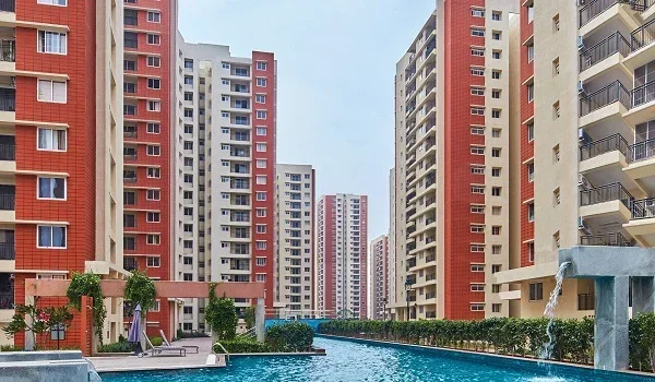
The Prestige Parklane residential precinct is spread across 11.90 acres, arranged as 9 towers of G + 24 floors rising to 76.55 m, holding 1,788 apartments that face a landscaped central park with a water body. The western half holds a self-contained enterprise estate of three data centres, a warehouse block and a manufacturing block, backed by a dedicated 220 KV on-site substation.
32.26 acres is the whole master plan, not the residential development. Homes occupy 11.90 acres of it, about 37 per cent. The remaining 20.35 acres are the enterprise estate. This is a conceptual layout and remains subject to revision.
How the Plan is Organised
A main boulevard runs through the middle of the site and does the separating. The residential precinct sits on one side of it, the enterprise estate on the other, and the two are planned to operate without crossing each other.
A single controlled entry and exit serves the whole estate. Tree lines run along every internal road, and the towers face inward onto a landscaped core with a water body rather than outward onto the industrial frontage.
| Element | Planned configuration |
| Master plan area | 32.26 acres |
| Residential development | 11.90 acres |
| Enterprise estate | 20.35 acres |
| Residential towers | 9, G + 24 floors |
| Tower height | 76.55 m |
| Apartments | 1,788 |
| Data centres | 3, B + GF + 6 UF, 46.20 m |
| Warehouse block | GF + Mezzanine |
| Manufacturing block | GF + Mezzanine |
| On site power | 220 KV substation |
| Entry and exit | One controlled point |
The seven blocks
Every block in the master plan, with the configuration drawn against it.
| Block | Configuration | Height |
| Residential precinct | Nine towers, G + 24 floors | 76.55 m |
| Data Centre 1 | B + GF + 6 UF | 46.20 m |
| Data Centre 2 | B + GF + 6 UF | 46.20 m |
| Data Centre 3 | B + GF + 6 UF | 46.20 m |
| Warehouse block | Ground floor with mezzanine | GF + M |
| Manufacturing block | Ground floor with mezzanine | GF + M |
| Substation | Dedicated on site power | 220 KV |
The Residential Master Plan, Block by Block
Two drawings describe the residential precinct. The master plan shows where everything sits. The numbering plan shows which unit type sits where inside it. Both are shared on request.
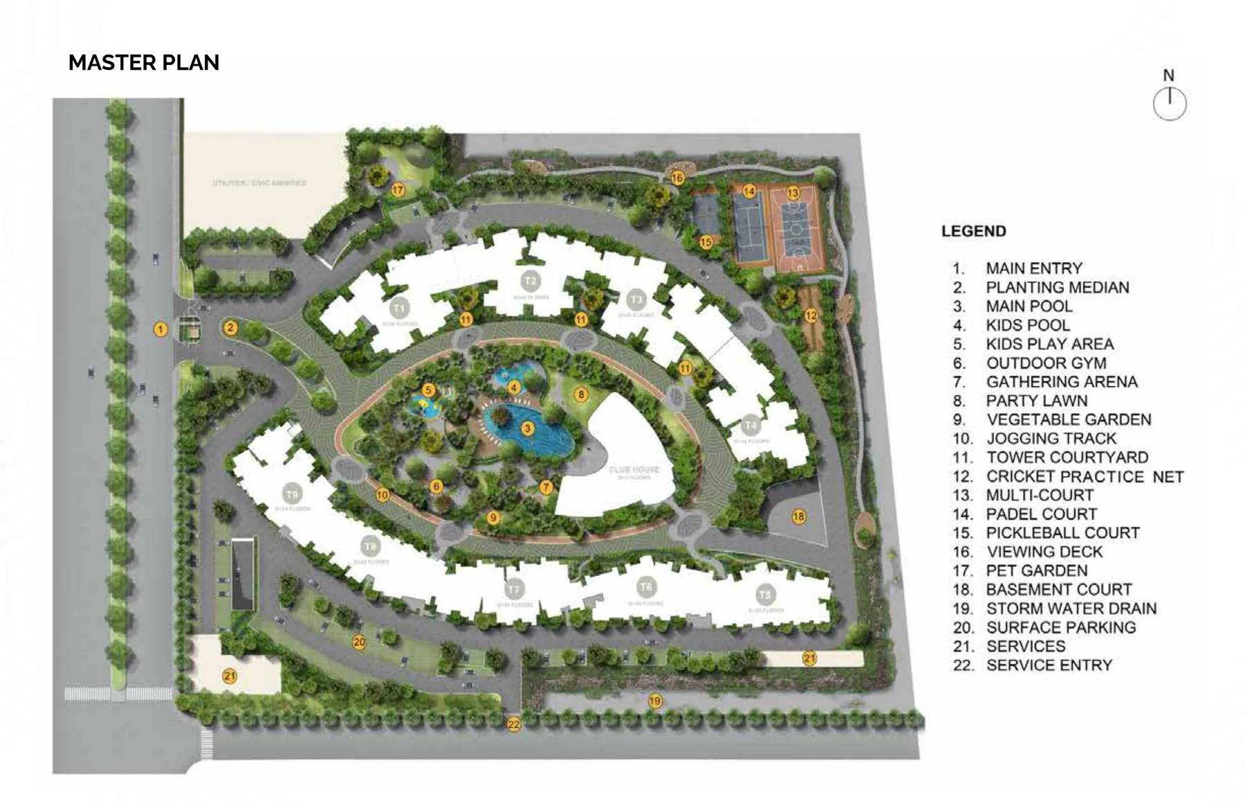
Master Plan
The whole residential precinct: nine towers as an arc around the landscaped core, the clubhouse, the sports courts, the entry off the boulevard and the utilities block, with every amenity numbered.
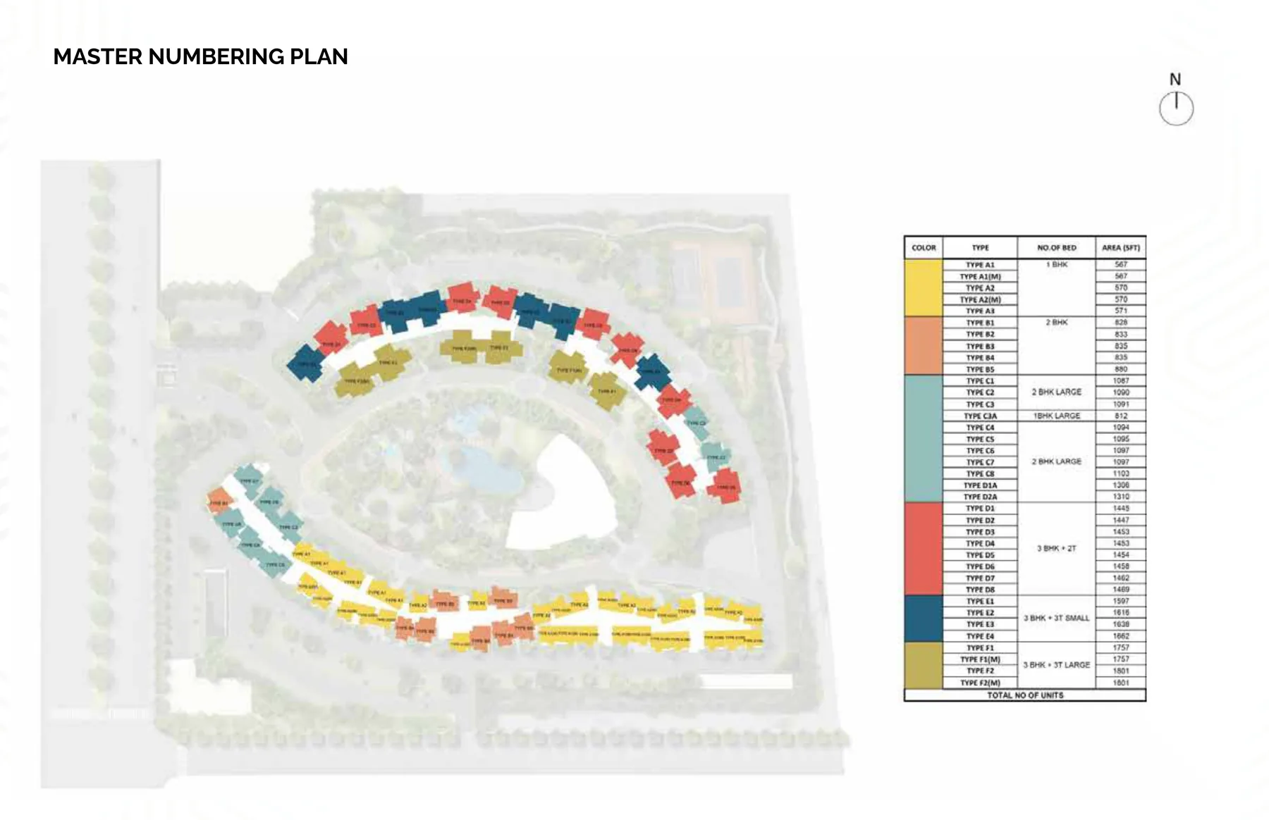
Master Numbering Plan
The same footprint, colour coded by unit type, so you can see which of the thirty seven layouts sits at which position in every tower before you choose a stack.
How to Read the Master Plan
North is at the top of the drawing. The wide tree lined boulevard running down the western edge is the spine of the whole 32.26 acres, and the arrow at its head points towards the Satellite Town Ring Road. Everything residential sits east of that boulevard; the enterprise estate, marked Technology and Logistics, sits west of it.
The arc, and why it is an arc
The nine towers are labelled T1 to T9 and every one is drawn as G + 24 floors. They are not laid out in rows. They form a broad arc that opens toward the south east, wrapping the landscaped core the way a horseshoe wraps its centre. T1 sits at the northern end nearest the entry, the sequence runs clockwise through T2, T3 and T4 along the northern and eastern edge, and T5 through T9 close the southern and western side.
The consequence is the point of the whole layout. Because the towers curve inward, the primary elevation of nearly every apartment looks across the landscaped core rather than at the perimeter road, the boundary or the estate opposite. An arc also means no tower directly faces another across a short gap, which is the usual failure of a rectangular block layout at this density.
What sits in the middle
The core holds the water, not the buildings. Reading the numbered amenities, the largest element is the main swimming pool with a second smaller water body beside it, a children's play zone to its west, and a jogging and walking loop drawn as a continuous track ringing the whole core. The clubhouse is drawn at G + 2 floors and sits on the southern edge of the core, inside the arc, so it is reached on foot from every tower rather than by crossing a road.
Sport is deliberately pushed to the edge
The tennis and basketball courts are not in the core. They sit outside the arc entirely, in the north eastern corner beyond T3 and T4, against the site boundary. That is a considered decision rather than a leftover: floodlit courts generate noise and light late into the evening, and putting them at the perimeter keeps both away from the apartments that ring the quiet core. It does mean the courts are a walk rather than a step from the southern towers.
Entry, utilities and the honest part
A single controlled entry comes off the boulevard on the western edge, with the first two numbered items at the gate. A separate block at the northern end is marked utilities and civic amenities, which is where the servicing that a development of 1,788 homes needs is kept, away from the residential frontage.
The thing the drawing shows that marketing copy tends not to: not every tower has the same outlook. T9 and the western towers sit closest to the boulevard, and therefore closest to the enterprise estate across it. T3 and T4 sit nearest the sports courts. The towers along the southern arc are furthest from both. All of them face the core, but what sits behind them differs, and on a site that deliberately puts homes and industry on one title that is worth walking before you choose a stack.
What the numbering plan adds
The numbering plan is the same footprint with every apartment coloured by type. It is the drawing that answers the question the master plan cannot: not where the towers are, but which of the thirty seven layouts you would actually be buying at a given position. Read across it and the distribution is legible. The larger three bedroom types cluster along the northern and eastern arc, while the one and two bedroom types concentrate through the southern and western towers.
That matters because two apartments of the same type in the same tower can face very differently, and the mirrored variants exist precisely to handle position. If you are choosing between stacks, this is the drawing to ask for. Every type and its area is listed on the floor plans page.
Both drawings are conceptual and subject to revision. Tower positions, amenity locations and the unit distribution follow the plan sanctioned by KIADB and filed with K-RERA, and nothing here should be treated as an allotment.
Frequently Asked Questions
1. What does the Prestige Parklane master plan show?
A 32.26 acre site split by a main boulevard. East of it sits 11.90 acres of residential development, nine towers arranged around a landscaped central park with a water body. West of it sits the enterprise estate: three data centres, a warehouse block, a manufacturing block and a dedicated 220 KV substation.
2. What is the total land area of the master plan?
The master plan covers 32.26 acres. That is the whole site, not the residential development. Homes occupy 11.90 acres of it, about 37 per cent, and the remaining 20.35 acres are the enterprise estate.
3. How many towers are in the master plan?
Nine residential towers, labelled T1 to T9, each planned at ground floor and twenty four upper floors, rising to 76.55 m. Together they hold 1,788 apartments across 11.90 acres.
4. What is in the enterprise estate?
Three data centres, each planned as basement, ground floor and six upper floors at 46.20 m, along with a warehouse block and a manufacturing block, both ground floor with mezzanine, and a dedicated 220 KV substation inside the estate boundary.
5. How is traffic and entry managed across the site?
A single controlled entry and exit serves the whole 32.26 acre estate, coming off the boulevard on the western edge. A separate block at the northern end is marked utilities and civic amenities, which keeps servicing away from the residential frontage. Tree lines run along every internal road.
6. How do I get the Prestige Parklane master plan?
Submit your name and mobile number through the enquiry form on this page. Our team shares the full resolution site layout with every block labelled, along with the master numbering plan showing which unit type sits at which position in each tower.
7. Is the master plan final?
No. The layout shown is conceptual and subject to revision. Tower positions, amenity locations and the unit distribution follow the plan sanctioned by KIADB and filed with K-RERA. Prestige Parklane Phase 1 is RERA registered under PRM/KA/RERA/1251/309/PR/150926/008941, and nothing shown here should be treated as an allotment.